Commission Mural here


METAL WORKS
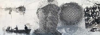
Mural location: Franklinton Columbus, Ohio
This mural illustrates the history of the Franklinton neighborhood, the 1913 flood, and the educating the public about the story of Entrepreneur Lyman Kilgore - owner of B&T Metals - one of the first African-American owned factories in the United States pioneering of aluminum production and being one of the only African-American owned factories of its day. Pictured in the center of the mural is Dave Tolbert, grandson of Lyman Kilgore.
In 1935, B&T moved to its location on West Town Street, combining their original factory with its factory at Gift and Rich Streets into one 100,000 square foot operation.
Link to more information on B&T Metals
https://www.ohioexploration.com/structures/btmetals/
FRANKLINTON 1913 FLOOD
Franklinton experienced extreme flooding in the Great Flood of 1913. After two days of steady rain, the wooden levees holding the Scioto River collapsed on March 25, 1913. The flood engulfed the neighborhood of Franklinton with 7–17 feet of water. Police officers in horse-drawn carriages traveled the flooded streets, warning residents to head to the higher ground of the adjacent Hilltop neighborhood. While recording the devastation of the flooding, Robert F. Wolfe, publisher of The Columbus Evening Dispatch, chartered an interurban train from Columbus to Buckeye Lake and took nine motorboats and 20 rowboats with him to the river's edge. From Rich & Scioto Street he was able to help residents who could not get to higher ground. The rising of the waters swept 93 people to their deaths and left 20,000 people homeless. It also destroyed nearly 500 buildings and every bridge in the downtown area. A large number of residents relocated to the Hilltop. As a result, property values dropped as much as 50 percent. Early estimates of the flood damage to homes and businesses came in at $5 million dollars with the eventual total climbing to $22 million. The damages from the Great Flood of 1913 led to some the first watershed planning and flood-control measures.[9][10][11][7]
The 1959 Flood was the last major flood to hit the Franklinton area. On January 22, 1959, the Frank Road crest on the Scioto River came and was 27.22 ft. above the flood stage level. The frozen ground throughout the area was partly responsible for the large volume and rapid rate of runoff of the heavy rain.[12]
From 1977 to 1985, the gay club Rudely Elegant operated on West Broad Street in Franklinton, in the art-deco Avondale Theatre. The club was notable for its street presence, at a time when Midwest gay clubs would be unmarked and accessed from alleyways. The club was open to straight people as well, and became known for its themed costume parties; some called it the Studio 54 of the Midwest. It was operated by Corbett Reynolds, a leading figure in the city's LGBT community, and now stands as a Lev's pawn shop.[13] The club and its owner were featured in a Columbus Museum of Art exhibition in 2019-20.[14]
In 1983, The Federal Emergency Management Agency determined almost all of Franklinton to be in a floodplain and at risk from a flood with a 1% chance of annual occurrence.[11] As a community that participates in the National Flood Insurance Program, the City Council adopted an ordinance that restricted new construction in the area. All construction in the area was to meet the minimum criteria of the National Flood Insurance Program. These restrictions caused Franklinton to have a gradual population decline.
During the latter half of the twentieth century, the construction of the Interstate Highway System had a major effect on Franklinton. The inner belt construction of the 1960s removed several buildings along Sandusky Street, resulting in lowered property values and driving families out of East Franklinton.[5] In addition to the land use and population changes that occurred, the inner belt formed a barrier which sealed off the side of East Franklinton that was not bordered by the Scioto River. This isolation was reinforced with the construction of West Interstate 70.
The Bottoms is a name for part of Franklinton, the first American settlement in Central Ohio dating back to 1797 and incorporated into Columbus, Ohio in 1870. The area is bordered to the east by Route 315, north by the Scioto River, west by the Interstate 70 overpass by Rhodes Park, and Brown Road on the southern border. The neighborhood originally got its name, Franklinton, from its founder, Lucas Sullivant. The nickname was originally coined because much of the land lies below the level of the Scioto and Olentangy rivers, and has historically been prone to flooding. The low-lying bottom land was well-suited for farming, with the river serving as a direct connection to the Ohio River. While the "bottoms" has often been used as a pejorative by outlying areas, many long-term residents are proud of the name. Since the early 2000s, the name "Franklinton" has seen a resurgence in use. Among some locals residents, the reversion to Franklinton is often associated with ongoing gentrification efforts, used as "the Bottoms" is an unsavory name.[1]
According to the Franklinton Area Commission:
-
Though Franklinton is the last downtown neighborhood to be redeveloped, it is actually the birthplace of Columbus, settled 15 years before the city itself
-
Since the completion of the flood wall, the community redevelopment has included more than 400 residential projects, a new firehouse, two new schools, new residential dorms at the former location of Mount Carmel West (which moved to Grove City) and the exploration of countless commercial projects
During the 1790s, Lucas Sullivant was a surveyor in the Virginia Military District. Like many frontier surveyors, he took his pay in land. The land he came to like best was on the western bank of the Scioto River in central Ohio at a place called the Forks of the Scioto. The Forks was the place where the Olentangy River, then called the Whetstone, joins the Scioto.
American Indians had been living at this place for hundreds of years and an American Indian village had been located as late as 1774 where the Arena District in downtown Columbus is today.
In 1797, Sullivant laid out a town on the west bank of the Scioto. He was a great admirer of Benjamin Franklin and named the town Franklinton.
The town lots were small, while farm lots on the outskirts of the town were considerably larger. Farmland generally sold for between one and two dollars per acre. Franklinton grew to become the most important community in the northern part of the Virginia Military District. In March 1798, a flood washed away the few houses built to that time. Rather than rebuild, Sullivant moved the entire town a quarter mile west to higher ground. In a short time, Franklinton had a growing population. Many of the homes were log houses or simple frame structures. Public buildings and the homes of prosperous people were built of brick or stone. By 1801, the community had grown so rapidly that residents advertised for a schoolmaster. Slowly the residents of Franklinton and other Ohio communities created a more settled life for themselves
Between 1803 and 1824, Franklinton served as the county seat for Franklin County. Franklinton became a major town during the War of 1812 when it served as a mobilization and training center for the army of General William Henry Harrison. Harrison held a major conference with Ohio's American Indian leaders in 1813 under an elm tree in the back of Lucas Sullivant's home.
Once Columbus became the state capital and the county seat, the community of Franklinton no longer grew at a rapid pace. By 1840, the community had 394 residents. In 1870, Franklinton was annexed to Columbus. The neighborhood was seriously damaged in a major flood in 1913. With the recent completion of a major flood prevention program, the neighborhood has seen significant growth and development. In 1997, Franklinton celebrated its bicentennial with the dedication of a statue of Lucas Sullivant along the Scioto riverfront.
source - https://ohiohistorycentral.org/w/Franklinton,_Ohio
150 ACRES before Columbus
Plat of Ohio's capital city, titled "A plat of the town of Columbus, laid off by order of the Assembly, for the seat of Government of the state of Ohio, 1817." Text at the bottom reads "Returned to the Assembly sitting in Chillicothe in the 12th month A.D. 1812 by Joel Wright Commissioner." This is a photostatic copy of the 1825 map which is a facsimilie of Wright's original 1812 map. This early plat of Columbus shows the Scioto River joined by the "Whetstone Branch," now the Olentangy River. West of the river is Franklinton, and "Prairies containing about 150 acres." Notable locations east of the river include the Public Square (location of the Ohio Statehouse) and the Ohio Penitentiary. The city was first laid out in 1812 and incorporated in 1816. Columbus was not the original capital, but the state legislature chose to move the state government there after its location for a short time at both Chillicothe and Zanesville. Columbus was chosen as the site for the new capital because of its central location within the state and access by way of major transportation routes (primarily rivers) at that time. Prior to the state legislature's decision in 1812, Columbus did not exist. The city was designed from the first as the state's capital, preparing itself for its role in Ohio's political, economic, and social life. In the years between first groundbreaking and the actual movement of the capital in 1816, Columbus grew significantly. The town was surveyed, and various city lots were put up for sale. By 1813, a penitentiary had been built, and by the following year the first church, school, and newspaper had been established. Construction on the statehouse began in 1814 as well. Columbus grew quickly in its first few years, having a population of seven hundred people by 1815. It officially became the county seat in 1824, and by 1834, the population of Columbus was four thousand people, officially elevating it to "city" status.
In February 1943, DuPont, acting as an agent for the Manhattan Engineer District (AKA the Manhattan Project), contracted B&T Metals to extrude rods of uranium metal pellets for the reactor in Hanford, Washington. The Manhattan Project was a top-secret project that took place from 1942 to 1946 to develop the first atomic bomb. Since the Manhattan Project was so secret, B&T workers and officials weren’t told of the ultimate plans for the uranium. They did not discover their link to the Manhattan Project until after World War II had ended. Even though it cannot be confirmed, uranium processed by B&T Metals could have been used for the bomb that Columbus pilot Paul Tibbets dropped on Hiroshima, Japan.
Metal Works Mural apparel here
•MURAL APPAREL